
« Géo.Kergaradec » : différence entre les versions
Aucun résumé des modifications |
Aucun résumé des modifications |
||
| Ligne 12 : | Ligne 12 : | ||
<mobileonly>{{#tag:iframe|level="www"|width="375px"|height="320px"|path="Zoomify/show.php?f=Cadastre1834.zif&x=3381&y=4181&z=50&m=small"}}</mobileonly><nomobile>{{#tag:iframe|level="www"|width="810px"|height="650px"|path="Zoomify/show.php?f=Cadastre1834.zif&x=3381&y=4181&z=50&m=big"}}</nomobile> | <mobileonly>{{#tag:iframe|level="www"|width="375px"|height="320px"|path="Zoomify/show.php?f=Cadastre1834.zif&x=3381&y=4181&z=50&m=small"}}</mobileonly><nomobile>{{#tag:iframe|level="www"|width="810px"|height="650px"|path="Zoomify/show.php?f=Cadastre1834.zif&x=3381&y=4181&z=50&m=big"}}</nomobile> | ||
[[:Template:Zshow | [[:Template:Zshow||zF=Cadastre1834.zif]] | ||
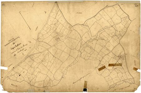
<p><big>B. Section du Bourg feuille 1 :</big></p> | <p><big>B. Section du Bourg feuille 1 :</big></p> | ||
Version du 27 juillet 2023 à 11:07
Contenu : Ensemble des cartes et plans historiques où figure le village.
Localisation : lat. 47.995565, long. -4.017885
Technique : Navigation interactive via les boutons +/- ou la barre de focale variable, et par glissement tactile ou curseur de souris.
Présentation du village, toponymie : « Kergaradec, Kergaradeg »
Espace carte : « Toutes cartes » ¤ « Cartographie des villages : K » ¤
Cadastre de 1834
A. Tableau d'assemblage :
B. Section du Bourg feuille 1 :
gmap3 f1=(Cadastre1834-Bourg-F1) n1="e" x1=6462 y1=2862
- Zoom à focale variable
Cliquez pour zoomer
Ref. : « Toutes sections du plan cadastral parcellaire Napoléon de 1834 ».
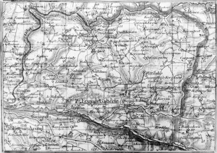
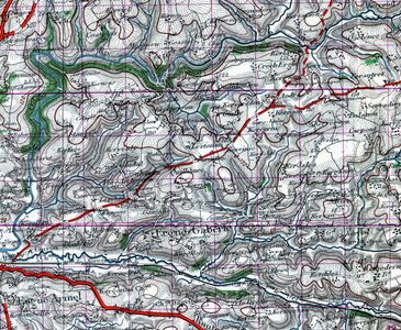
État-major 1860
<gmap3 f1="EtatMajor40000" n1="e" x1=2214 y1=2601></gmap3>
- Zoom à focale variable
Cliquez pour zoomer
Etat-Major 1920
<gmap3 f1="EtatMajor1919" n1="1" t1="800,450" t2="830,500" x1=1598 y1=1831></gmap3>
- Zoom à focale variable
Cliquez pour zoomer
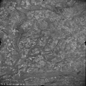
Vue d'avion en 1948
<gmap3 f1="1948-EG-West" x1="7550" y1="6850" h1="Hotspots/KegaradecV3.xml"></gmap3>
- Zoom à focale variable
Cliquez pour zoomer
Carte de 1950
<gmap3 f1="EGCarte1950" n1="1" t1="800,450" t2="830,500" x1=2597 y1=3512 i1=0></gmap3>
- Zoom à focale variable
Cliquez pour zoomer
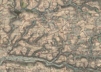
Carte I.G.N. actuelle
<gmap3 f1="Ergue-GabericIGN" n1="1" t1="800,450" t2="830,500" x1=2705 y1=3201></gmap3>
- Zoom à focale variable
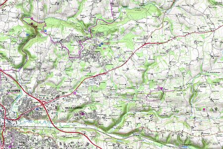
Cliquez pour zoomer